Author: Jenny Oliver
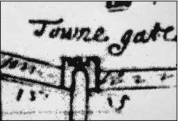
In the late C16th the town of Pooleoccupied only the peninsular south of the present railway line. The first detailed street map, the Pythouse map of c. 1630[1], shows a roughly oval area of land, with the clawed shingle spit of Baiter extending to the east. The town defences, consisting of a wall and ditch across the neck of land connecting Poole to the mainland, were constructed in C15th after Poole was made a Port of the Staple or customs port. The only land access to the town was over a drawbridge and through the towngate, a gatehouse of stone with two round castellated towers, located beneath the present Towngate Bridge. An old, possibly Tudor, fortification known as the bulwark was situated on the tip of the Hamworthy peninsular. More defences, including a fort at the western end of the ditch and a half-moon in front of the towngate were constructed during the Civil War. In the 1650s the town walls and gate were demolished and the ditch filled in.
In Tudor and Stuart times, Poole contained quite a lot of open space in the form of fields, closes, gardens and orchards, and many animals were kept there including horses, pigs, cows and poultry. In C16th, the town’s herd of cows was led out every day to graze on the heath. The town retained this rural aspect during most of the period and building development was slow, accelerating in the later C18th.
The facilities of the portconsisted of the public quay, known as the Great Quay, the town cellars for storage, the town beam for weighing goods, the use of carts, and the services of pilots, porters and bearers. There was also a ballast quay on the Hamworthy side of the water. Merchants from other ports paid charges of keyage, cellarage, beamage and cartage for using these facilities according to a fixed rate, and a 1579 list of rates for different commodities exists in the archives.[2] During most of the period, the Corporation operated the port directly and it was the responsibility of the annually elected Water Bailiff or his deputy to collect the dues. Sometimes the collection of port dues was leased out to individuals for an annual rent. In 1620-1, for instance, John Bramble leased the keyage and other port dues for £16 a year. The town accounts show a range of goods coming through the port, including foodstuffs like beer, wine, sack, hops, salt, wheat, beef, fish, oil, raisins and oranges and other commodities such as iron, copperas, stone, coal, cloth, canvas, leather, nets, pitch, tar and soap.

In 1580 the Great Quay consisted of a single row of buildings including the town cellars. According to a 1558 description of the bounds of the quay, it was 240 ft (73m) long from the corner of James Measurer’s house in the east to the quay head in the west and 48 ft (14.6m) from north to south. A passage boat service operated from the quay to Hamworthy, usually leased out by the Corporation for an annual rent. A map of c. 1597[3] (with south at the top) shows the Quay, Thames Street, Salisbury Street and ‘Measurer’s Gap’ (an inlet in the shoreline east of the Great Quay).
Around 1618, funds were raised for building a new quay and a fish shambles (market) at Measurer’s Gap, finally completed in 1620-1. This was ‘set forthe 8 or 9ft’, and there was also a slip for loading horses. Over time buildings were constructed on this extension of the quay. The Admiralty Court often recorded that the quay was in bad repair, and payments for work on the quay frequently appear in the town accounts.
In 1660, the quay was described as being only 192 ft (58.5m) long from a wall by Henry Harbin’s house used for heating pitch, to the quay head, with a pair (set) of stone steps in the middle. As this section of the Pythouse map of c.1630 shows, the apparent reduced length of the Quay was the result of the New Quay overlapping with it. (The map is shown with south at the top for comparison with the 1597 map.) The 1660 description also mentions that the lands and warehouses of John Webb Esq., Lord of Canford Manor, and the house and land of Dennis Smith, merchant were at the northwest side of the Quay.
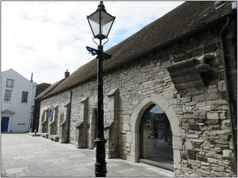
The Town Cellarswas built in the early C14th as a port warehouse and was originally called the Woolhouse or the King’s Hall. Wool and cloth were the main commodities originally stored there but by the late 1500s, it housed a variety of goods. The building was 36.5m long and 7.5m wide, with walls 1m thick, constructed of coursed Purbeck limestone and carstone rubble. The building may have been damaged in the joint Spanish / French raid of 1405 and was partly rebuilt in the mid C15th, most of the south wall and the roof dating from this period.
The 1597 quay map shows direct access through from Thames Street to the Quay and there is evidence to suggest that there was an arched cart entrance through the building. Internally it seems to have been divided into several different stores. It is not known who built the cellars but it was probably the Lord of the Manor of Canford. Over the centuries the cellars together with the port dues were leased to individuals and in 1577 the then current holder William Mallock leased them to the Mayor and Burgesses of Poole. During the C17th, the Corporation occasionally rented out the building and the collection of port dues to various businessmen of the town.
The Custom Housein Pooledates fromwhen the town became the Port of the Staple for Dorset in 1433 by letters patent from Henry VI. We do not know the location of the earliest Custom House, but a reported mortgage document of 1736 mentions a property, the inheritance of Elizabeth Harbin, ‘formerly called by the name of the old Custom House’. This property is described as beingnear the Quay with the High Street on the east, the town cellars on the south and the sea on the west, therefore probably in or near Salisbury Street.
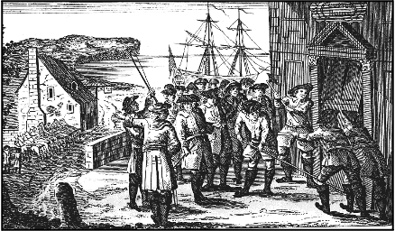
In 1705, an old house on the New Quay, more or less on the site of the present Custom House, was converted and leased to the Crown by the Ledgard family as a Custom House. The building was quite spacious but rather inconvenient for its purpose. In 1747 it was raided by smugglers. A print depicting the raid shows the building but there is doubt about its accuracy, as the surrounding scene looks nothing like Poole.
Other public buildingsin Poole included the church of St. James, dating from the late C12th with a later tower and north and south aisles. The town house in Fish Street (now Castle Street) was built in 1572 after the granting of the Elizabethan charter and was used as a Corporation chamber and courtroom. Later it was also used as a prison. There was also a market hall near the site of the present guildhall and two almshouses, the old one in Church Street, dating from the early C15th and the Rogers’ almshouse in West Street, built in 1604 from a bequest in the will of Robert Rogers. A windmill and mill-house, originally built in the time of Henry VIII, were located at Baiter and a school was founded in 1628 in Thames Street by merchant and current mayor, Thomas Roberts. The small lock-up known as the Salisbury was located behind the town cellars and the town also had a pound for straying animals, a set of stocks and a cucking or ducking stool which was operated over the Quay.

At the beginning of the period Poole had a mixture of medieval stone houses and half-timbered Tudor houses, some of which still survive. A block of buildings on the northwest side of lower High Street for instance, are Tudor or older although this is not obvious from their altered exteriors. Smaller Tudor houses on the southeast side of the street survived until the 1960s and 1970s and there are other Tudor survivals here and there such as Byngley House, No. 6 Market Street. The largest and most affluent properties were probably in High Street, Thames Street, Church Street and Market Street. In C17th, a few of the larger houses such as Scaplen’s Court were converted into inns, and some leading citizens chose to live further north in the corn market area of High Street. Few buildings survive from the C17th but many more from the C18th. The earliest of the Georgian mansions was probably No. 87-9 High Street, now Ginali’s restaurant, which dates from 1704 and was probably built by the merchant Samuel Weston. It was originally seven bays wide with wings front and rear.
No. 87-9 High Street as it may have looked originally.

Records show that in 1620 the town had 4 inns and 18 alehouses. These probably included the Antelope, the George and the Bull’s Head in High Street, the Rising Sun in Fish Street and the Three Mariners in Market Street, providing accommodation for travellers and horse stabling. Also frequently mentioned in property documents are bake-houses and brew-houses, (beer being a major trade in Poole). Houses, workshops and retail shops would often be combined in one property. Many merchants had private cellars to store their goods (the word not implying that they were underground). Eleven such cellars are mentioned in a tax list of 1662.[4] Apart from Paradise Cellars which was next to the town cellars, we do not know the precise location of these but most would have been around the Quay.
The shoreline to the east of the great quay was a shingle beach, backed by the houses on Strand Street. Narrow paths or lanes between the houses on the south side of the street gave access to the shore. Apart from the building which is now the Poole Arms, there seems to have been little construction between the houses and the sea in the early 17Cth, but property documents record a process of reclamation and building throughout the century.
The rear of the Poole Arms
In 1697, a tax list gives the impression of a tight-knit community living in Strand Street and the nearby lanes and alleys, with certain family names, Sutton, Wills, Thompson, Parsons, Bennet and Weston recurring frequently in the list of residents.[i]

In 1723, the Corporation decided to carry out a survey of reclamation along the shore, particularly in the area between high and low water mark, which was considered waste land belonging to the town. Some of this reclamation consisted of enclosing land with walls or fences; elsewhere people had constructed buildings, piles, jetties, quays or other structures. Many cases related to the Strand Street area. Giles Hozier, for instance, had ‘erected a building near Bennet’s old house’, and John White had built a quay ‘against the land of Giles Hozier’. A quay called Parson’s Quay had been built on waste ground belonging to the Corporation and Charles Anstey, a mason and bricklayer, had ‘taken in and built on a piece of Corporation property 14 ft long and 18 ft wide and also built a quay outside this building.’ Thomas Nicklesonwas reported for ‘enclosing a quantity of ground from the sea to make a quay by throwing dirt, earth and rubbish therein’. As more of the foreshore was built up, the paths between the houses had developed into long narrow alleyways, leading to the sea.
Other stretches of shoreline had also been reclaimed. John Darby, a rope-maker of Hamworthy, had ‘erected five posts in the waste land there and intends to make a ropewalk 190 ft long’. This was officially regarded as a nuisance. Robert Randall had begun to build and encroach upon the Little Quay in a way which was regarded as a hindrance to trade, and the porters and bearers were ordered to demolish the building as often as it was put up. Mariner Alexander Smith had also been active building a wall to enclose land in West Street from the turfhouses down to the sea without Corporation permission. In a few cases, the Corporation demanded that buildings were demolished but mostly they accepted the status quo and started charging the property owners rent for their plots.
By the middle of the C18th, maps show a lot of building around the shore, with a piecemeal development of stores, quays, workshops and yards.[iii] Mid-century tax lists show that this was an area where maritime trades such as ship and boat building, sail-making, block-making and cooperage were carried on. Ropewalks were established on the south Hamworthy shore, at Longfleet and Baiter Green. On the shore beyond West Street were timber yards and boat yards, many of them owned by leading C18th merchant families. A mixture of commercial and residential development had also spread along the main streets, filling in some of the open spaces between buildings.
Bibliography
[1] Plan of Poole 17th century (copy Dorset History Centre Ph 844)
[2] Poole History Centre copy.
[3] Part of a Plan of Brownsea Island and Castle 1597 Cecil Papers (copy Dorset History Centre Ph 403)
[4] Six month’s assessment on Poole 1662. National Archives E179/245/24
[5] Poor rate tax 1697
[6] Survey of Encroachment, Enclosures and Nuisances made within the limits of the Town 5 June 1723
M. 23
[7] Sir Peter Thompson map 1751, Hutchins Map 1774.
One reply on “Town and Port of Poole, 1580-1730”
Interesting and detailed. Well done.